In the first post in this series, you learned how Beth and I use Trello, Evernote, Instagram, Panoramio, Chimani and Google Maps to start trip planning and decide where we’re going. In reality, that part of planning really only scratches the surface, as there are many more factors that affect how we get to where we’re going.
In this post, you’ll learn about several additional tools we use to figure out exactly how we’re going to get there, taking into account time, distance, clearances, grades and fuel costs.
Sadly, no single trip planning app does everything we want perfectly, but we’ve managed to put together an ensemble of free and inexpensive tools that work reasonably well together when planning your cross country road trip.
Let’s face it, until you’ve driven a 13’ tall, 10’ wide, 18,000 pound vehicle, you probably never put much consideration into things like low bridge clearances and road grades when taking a road trip (or at least, we sure didn’t).
Which Trip Planning App Should You Use?
After our first two jaunts, we quickly realized that Google Maps just wasn’t going to cut it for planning our road trip, so we started looking into other tools. The following tools are the trip planning apps we consider to be “best of breed.”
Using Google Earth to Visualize Your Road Trip
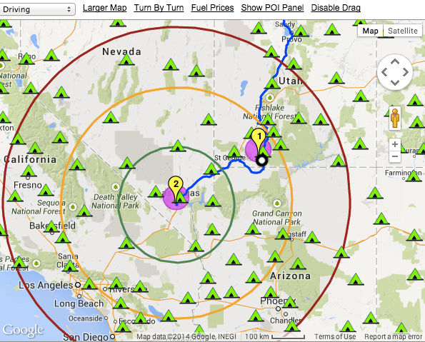
 When I first realized the limitations of Google Maps for plotting our cross country road trip, I turned to Google Earth for its superior multi-point routing capabilities. While Google Maps does fine with point A to point B (and even A to B to C, now that the new version once again supports multi-stop routing), it lacks the visualization features necessary to make it an effective tool for truly planning an extended road trip.
Google Earth is a very cool tool for exploring the planet, and its ability to import KML files makes it easy to use in conjunction with Google Maps to store and share routes and destinations.
Still, for routing a large RV across the United States, Google Earth lacks the necessary capability to identify and avoid low bridges and steep hills that might otherwise ruin your day.
Although Google Earth isn’t our primary routing tool, it’s still useful to save, store and share routes, and these two excellent posts go into great detail about using Google Maps and Google Earth together, and Creating KML Files:
One of the coolest features in Google Earth is the ability to view photos from Panoramio overlaid onto the map by enabling “Photos” in the Layers panel. In this video, I walk you through exporting a route from Google Maps Trip Planner as KML, then importing it into Google Earth and turning on the Panoraio Pictures layer:
[video_youtube video_url=”http://www.youtube.com/watch?v=74ya9t50Mnw” width=”480″ height=”360″]
If you want to get your own photos into Google Earth, you can upload them directly to Panoramio. For more info on the process, check out this how-to guide from Google:
Getting your photos into Google Earth
Using Garmin BaseCamp for Offline Trip Planning
 Like Google Earth, Garmin Basecamp is designed to plan, organize and share road trips. Both tools show topographic data and can plan routes for cross country road trips. In 2013, Basecamp even added “RV” and “Truck” profiles with special routing options. Because we have a Garmin RV 760LMT GPS (we also bought the backup camera), I spent quite a bit of time trying to get the Garmin route planner to do everything we need it to do, and admittedly, it comes close.
 Still, the Trip Planner mode is a little bit clunky because it’s oriented entirely around the dates and number of days you plan to stay at each destination. While this is fine if you have specific days and dates planned for each leg of your trip, when you’re full-timing like us, days and dates tend to change frequently and are rarely set in stone. 🙂
Also, even when using the BaseCamp route planner’s RV mode, I’ve found the list of low clearances to be incomplete, and indeed BaseCamp would have routed me via some roads that I wouldn’t have wanted to drive based on additional research I did using the Mountain Directories and LowClearances databases (see below).
Still, I find that having a good routing tool with a reasonably accurate overview of topography helps me to get a better idea of how to circumnavigate some of the more difficult terrain we might encounter. While both Google Earth and Garmin BaseCamp could fit the bill, BaseCamp has the edge over Google Earth in this area simply because we can use it offline (without internet access). So, even though BaseCamp isn’t my primary trip planning app, I do still reference it occasionally as I’m planning the longer legs of our journey.
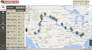
Good Sam’s Trip Planner is the Easiest to Use
Important note: There are two versions of the Good Sam Trip Planner, the old trip planner and the new trip planner. In my humble opinion, the old trip planner was horrible, and barely worth wasting my time playing with. The new trip planner is much better, and even if you don’t use it as your primary routing software, it is well worth considering. As of 8/24/14, I can no longer find links to the old trip planner, so it appears that the new trip planning app is now standard.
Also, it’s important to note that you’ll have to be a member of Good Sam Club in order to use their Trip Planning app. Membership is cheap (only $15/year if you prepay 3 years in advance) and also gets you discounts at Camping World, Pilot Flying J gas stations and hundreds of RV parks.
 When I first found the Good Sam Trip Planner, I thought I’d finally found the perfect RV trip planning app.
Unfortunately, after working with it for several months, it has shown itself to have some of the very same flaws as the earlier tools I reviewed, although it is much easier to use and prettier to look at than several of the other tools I played with.
In fact, I find the Good Sam Trip Planner to be the nicest looking and easiest to use tool of all the route planning software I’ve looked at to date.
Interestingly, the Good Sam Trip Planner is powered by Rand McNally, though I’ve found Rand McNally’s own routing software to be rather lackluster. Regardless, they did a pretty good job with the new Good Sam trip planning app, so I won’t complain.
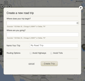 Creating trips in the Good Sam Trip Planner literally takes two clicks. Once you’ve added a couple of simple details about your trip, you will be taken to the main trip planning interface, which is broken down into five tabs:
- Trip Manager
- My Trips
- Search
- Campgrounds
- Things to Do
My Trips is where you manage multiple trips or routes, and Trip Manager is where you’ll spend most of your time while planning your route, although you’ll likely jump back and forth to and from the Campgrounds tab as you look for spots to stay along the way.
The Good Sam Trip Planner breaks campgrounds down into Good Sam RV parks, Public campgrounds, and Private RV campgrounds. However, because this post is mostly about “how to get there,” I’ll wait to explain more about the Campgrounds tab and “where to stay” in the next post in this series.
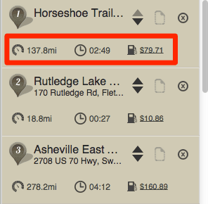 In addition to the clean interface and simple layout, one of the most useful capabilities of the Good Sam road trip planner is the display of mileage with cost and time estimates for each leg of your journey (as well as for the entire trip). To us, this is essential for planning because we don’t like to drive more than 4 or 5 hours per day when we can easily avoid doing so. Plus, seeing the cost of each leg of the journey helps us better plan how long we might want to stay at each destination.
Another nice feature of the Good Sam Trip Planner is the ability to automatically identify “RV warnings” which include things like low clearances and restricted use roads or tunnels.
As with other trip planning apps mentioned previously, the Good Sam Trip Planning app still doesn’t manage to catch all of the critical low clearances, and even worse, it has actually suggested routes with such incredibly severe road grades that we likely would have burned up our engine or our brakes if we had even attempted them! For this reason, regardless of which of the travel planners you decide to use, I would strongly suggest that you pay very close attention to the section on the Mountain Directories and Low Clearances below and always double check your route using more than one tool.
Frankly, until late July, the Good Sam Trip Planner was the best road trip planner I’d found (and the only one I was using consistently), until Bob Freelove read the first post in this series and encouraged me to give RV Trip Wizard another chance.
Overall, the Good Sam Trip Planner is definitely one of the best road trip planner apps on the market, and considering the minimal cost of Good Sam Club membership (and the other added benefits club membership provides) I’ll certainly continue to use it every time I plan a new leg of our journey (although I will always double check suggested routes using RV Trip Wizard and the Mountain Directory).
RV Trip Wizard is A Fantastic Trip Planning App
 Early on in our travels, I spent quite a bit of time researching road trip planning websites and apps, and RV Trip Wizard was actually one of the first tools I looked at. Unfortunately, the RV Trip Wizard website isn’t that great (sorry, guys), and even though they offer a “free demonstration” route, since I wasn’t able to put RV Trip Wizard through its paces with my own route, I never really got a feel for just how useful the tool actually was.
Fortunately, fellow RVer and travel blogger Bob Freelove read the first post in this series, after which he sent me a very nice email thanking me for putting together the information in that post. After a brief conversation about mapping tools, Bob convinced me to give RV Trip Wizard another look, and suffice it to say, I’m very happy that I did.
Although I do find the RV Trip Wizard interface to be a bit more cumbersome than Good Sam’s Trip Planner interface, RTW essentially overlays their interface on top of Google Maps, so manipulation of the map itself is pretty intuitive. Managing stops isn’t as easy as with the Good Sam tool, but as you’ll see, the added capabilities make RV Trip Wizard worth the additional kludge.
Like the Good Sam app by Rand McNally, RV Trip Wizard is one of the only apps that also provides time and fuel cost calculations for the route. Even better, they’ll also allow you to set average amounts you expect to pay for campgrounds, meals and other miscellaneous daily expenses, and use that information to calculate an estimated total cost per day which is incredibly useful when road trip planning (and much more so than the simple fuel cost calculation provided by Good Sam).
Another very useful feature is RV Trip Wizard’s “bounding radii,” which make it much easier to determine the minimum and maximum distances you’ll probably want to travel one any one leg of your journey. Although the radii are measured “as the crow flies,” they still provide a good reference to help you determine how far you’ll be able to drive each day.
 Whereas the Good Sam tool only organizes RV parks into three categories (Good Sam RV parks, Public campgrounds, and Private RV campgrounds) RV Trip Wizard identifies literally thousands of RV parks, campgrounds and outdoor resorts and organizes them according to club membership (with about a dozen supported membership clubs), or as National Parks, State Parks, National Monuments, National Seashores, State Beaches plus about a 30 other extremely useful categories.
So, after putting the RV Trip Wizard through its paces to calculate the three most recent legs of our journey, and comparing it to Garmin BaseCamp and the Good Sam Trip Planner, I can now say that RV Trip Wizard is indeed a superior route planner and the first trip planning app I rely on when hitting the road.
Check out this RV Trip Wizard review video I just uploaded to our YouTube channel:
[video_youtube video_url=”https://www.youtube.com/watch?v=8nqIY4EuZpc” width=”480″ height=”360″]
Staying Safe on Your Cross Country Road Trip
Unfortunately, as I alluded to earlier in this post, none of these travel planners is perfect, and none of them really do an effective job of routing around steep grades, even if they do manage to avoid some (or even most) low clearances.
Avoiding Dangerous Mountain Passes and Steep Grades
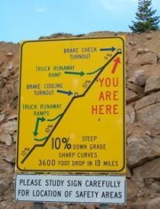 As Beth and I left North Georgia headed for Asheville, North Carolina, we immediately became aware of just how much road grades impacted our travel. Not only can it be tough to climb a 7% grade in an 18,000 pound vehicle towing a 4,500 pound car, but it can also be pretty tough to slow down or stop quickly as you head back down the other side of the mountain.
Although we’d first experienced some of these same grades on our maiden voyage to Louisville, Kentucky several months before, we’d done so with a mostly empty coach and no toad, which probably amounted to a difference of at least 6,000 pounds. Even then, going up some of the bigger hills put a noticeable strain on the engine, and hearing the brakes squeal while descending was more than a little disconcerting.
After quite a bit of research, we came to the conclusion that there just aren’t a ton of reliable sources for information about mountain passes and steep grades. Sure, you can find recommendations from other truckers and RVers in some of the RV forums and you can scour topographic data in Google Earth or Garmin BaseCamp. Unfortunately, neither of these is consistent or reliable enough to save you from the worry of burning up the engine in your gas-powered class A motorhome, or setting fire to your disc brakes as you make your way through the Blue Ridge or Rocky Mountains.
 As such, the most comprehensive resource we’ve found for road grade information is the Mountain Directory series of “books.” I use the term loosely, as we chose to purchase the “ebooks” rather than the printed books. Unfortunately, the “ebooks” are actually Windows applications, and since Beth and I both use MacBooks, they’re a bit of a pain in the ass to use. We manage by using VirtualBox (you could also use VMware Fusion or VirtualPC) to run Windows on our Macs, but I’ll certainly be purchasing the printed books before we get back on the road.
I’ll admit that I’m not a huge fan of the Mountain Directory ebook interface (the ebooks are basically web pages embedded in a Windows executable), but it’s still 1,000 times better than glancing at topographic maps and guessing whether or not we’ll run into trouble.
In fact, had it not been for the Mountain Directory West ebook, we would have taken a route suggested by the Good Sam Trip Planner that would have taken us on a road with 10% grades both up and down a mountain pass, with dozens of hairpin curves and switchbacks!
Even if we hadn’t fallen off the side of a mountain, I’m about 99% positive that Beth would have had a stroke or a heart attack before we made it to our destination, so I consider the Mountain Directory guide to literally be a life saving trip planning app. 🙂
Avoiding Collisions and Low Clearances
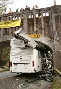 Although most of the resources discussed in this post do their best to take into account low clearances, none of them is as comprehensive as someone with at 13’ tall (or taller) vehicle should accept. Even though our Garmin GPS has done a pretty good job of routing us around low bridges, one simple omission could result in a huge loss of time and money by forcing us to backtrack and re-route our trip. Even worse, if you don’t realize you’re approaching a low clearance, you could end up shaving off your air conditioners or even the entire roof of your vehicle if you’re not careful!
From our research, the route planning tools and websites mentioned above use databases with between 300 – 500 bridges and low clearances. Most “RV GPS” units have larger databases with around 1,500 low clearances. However, on a recommendation from our good friend dc0de, we discovered LowClearances.com, which maintains a database of over 4,000 low clearances that you can download and use in conjunction with most of the above trip planning apps or install onto your own GPS unit.
That means that your GPS or route planning tool may be missing as many as 3,500 low clearances that you could otherwise encounter on your cross country road trip. Yikes! In fact, Route–1 estimates that there are an estimated 5,000 low hazard collisions in the USA each year, causing over $100 million worth of damage to public and personal property!
Considering that the complete USA and Canada databases with lifetime updates only costs $75, we consider it a small price to pay to make sure we don’t contribute to next year’s statistics.
On dc0de’s recommendation, we’ve now installed the low clearances database on both our Garmin GPS and into Garmin BaseCamp to make sure we don’t get surprised by obstacles or clearances that our other trip planning apps might have missed.
FuelMyRoute, MyPilot and GasBuddy Save You Money
Although both the Good Sam Trip Planner and RV Trip Wizard provide fuel calculations for route planning purposes, they don’t provide quite enough information to ensure that we always:
- Save the maximum amount of money on gas (or diesel)
- Stop at the right times to ensure we never get too close to empty.
In order to ensure that we get the best prices on gas and never break down, we use a combination of three free apps to plan out our fuel stops along our route.
Notice: As of 02/02/2015, FuelMyRoute.com has (unfortunately) shut down.
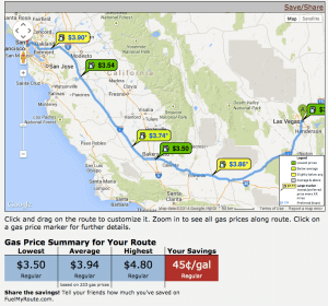
FuelMyRoute.com is a simple and effective website designed to help you plot your fuel stops for your road trip. In addition to plotting the lowest cost gas stations along your route, you can specify maximum travel distances between stops (based on your tank size and average mileage estimates) and gas stations to prefer or avoid. Since we have a Costco membership (where gas is often $.02 – $.10 cheaper than other stations) and our Good Sam Club membership saves us $.03 per gallon at Pilot Flying J truck stops, we’ve found that FuelMyRoute can save us up to $.50 per gallon on long trips.
On a 500 mile leg, that could easily translate to a $40 – $60 or more savings on fuel alone!
Because there are times when we may change our route on the fly, we also make pretty good use of the MyPilot iPad app, which allows us to easily map out the nearest Pilot Flying J truck stops and see ratings for the stations (with additional useful information, like user reviews of the cleanliness of restrooms and showers) as well as up-to-date prices on fuel and propane.
Finally, once we’re parked at our destination and cruising around town in our toad, we tend to rely on the GasBuddy app for iPhone and Android, which allows us to locate the cheapest gas stations at a moment’s notice.
Route Plan Like a Pro
After using virtually every route planning tool available, I can safely say that none of these tools is perfect, or even good enough to be used on its own. Some are better at somethings than others.
If I could only use one trip planning app, it would be a toss up between the Good Sam Trip Planner and RV Trip Wizard, with a slight edge given to RV Trip Wizard because it hasn’t yet tried to route me up and over a 10% grade. 🙂
Still, if you want to plan a cross country road trip that is safe and fuel efficient, without spending weeks planning, you should really consider looking to third-party databases like the Mountain Directory, Low Clearances and fuel databases mentioned above.
At the minimum, they’ll probably save you a few hundred dollars on gas, and at best they’ll save you hours or days of travel and quite possibly, the engine, brakes and roof of your RV!
Across later posts in this series, I’ll show you the best ways to figure out where to camp, where to eat and how to completely avoid bad weather.
Have we missed anything?
If you haven’t read part 1 in this series, make sure to check it out here.
Have a favorite tool or tip that we should add to our list?
Please let us know in the comments section below!
Thanks for reading. We hope you enjoyed our Ultimate Road Trip Planning App guide!
49 responses to “9 Awesome Trip Planning Apps. Number 7 Already Saved Us $420!”
Love your informative travel posts. Because of your testing I will give your recommendations a try. Thank you!
Thanks, Patty! We’re still learning all the time, and it’s wonderful validation to hear from folks who get value out of the lessons we share!
I am so happy I read this and you mentioned LowClearances.com; I went right over and bought it! I have the truckers Atlas that I always check against, but this will make my life much easier.
Kerensa, so happy this helped you!
We were also quite pleased to find LowClearances.com (a big thanks to our friend dc0de for the recommendation), and the Mountain Directories as well… without them, we wouldn’t have known better than to to trust the Good Sam Trip Planner, and we would have ended up trying to drive over a pretty steep pass in Wyoming that I’m not sure our gas-powered Class A would have been able to muster!
Hi Beth & Taylor,
Just a quick thank you for the great trip planning tips and resources!!!
Bernard
You’re very welcome, Bernard, glad you found the info useful!
We’ve never tried any of these, can you believe that?? But I’m trying out the Good Sam planner now for our travels north through Jerome, Sedona, Paige, etc. We don’t want to miss out on anything!
Sweet! Yeah, in the beginning, we tried to rely exclusively on Google Maps… but because we were so nervous about grades and clearances, I started looking around for better tools. Now, instead of using one simple tool that’s missing tons of features, we use 3 simple tools that are missing tons of features, but our results are generally pretty good, and like you guys, we’ve found a few spots along the way that we almost certainly would have missed had we not employed a few of these gems. 🙂
We have full timed for over 5 years and I’m a planner. Often broad brushing a trip over a year in advance. Most of the planning is on the PC so I like MS Streets and Trips; however that Is no longer supported. I can do this without using the Internet. But I’ll take a look at your suggestions. Thanks
Thanks, Roger. I also like having backup tools that don’t rely on the internet, but admittedly, it’s much harder for those resources to stay up-to-date. Glad you found our post, and I look forward to hearing more of your thoughts once you’ve had a chance to try a few of these tools!
i also prefer streets and trips from MC. i used it for years.used it this last year. problem its still better then anything i have found. what i want is easy trip change, gas reminders, offline. do you have anything you can think of that can do ALL THAT MC DID?
I went to the App Store and tried to Download the Good Sam trip Planner and also the RV trip Wizard and neither of them showed up in the App Store. Is there somewhere else that I can get these programs? Thanks so much for the info in the article.
Ray,
Both Good Sam Trip Planner and RV Trip Wizard are web apps, so you can just click on them above go to their websites. 🙂
Taylor, my problem with the Good Sam planner is if you want to modify your trip by using a different route you have to create a waypoint to drag the route for every change, sometimes extended routes require multiple waypoints and when you save the trip to your SD card for my factory installed GPS on my Winny, and you do not delete a waypoint while you are enroute it confuses the GPS until you do delete it. You have to navigate multiple screens to do so. And if you delete all the waypoints at one time, it will refer to the original route it recommended and override the route you planned. I contacted the manufacturer and they confirm that others have complained about it as well. they say they have no plans to upgrade as of now but if you could create your own trip and modify the trip using some routes other than the recommended ones and then SAVE it without the waypoints it would be a great tool.
Ray
We don’t use the “export to GPS” feature in the Good Sam Trip Planner because we don’t have a Good Sam or Rand McNally GPS, so I just use it for planning purposes, then add the stops to our Garmin RV 760LMT GPS manually. Have you tried using the export to GPS feature in RV Trip Wizard?
Take you for sharing your research! Very informative and helpful!
We have been full time RVers in a Diesel Pusher Motorhome for four years. I have been looking for more effective, save and intuitive routing tools.
I will add RV Trip Wizard and LowClearances.com to our tools.
Thanks again, and safe travels!
Awesome, thanks for commenting, Jack! Look forward to catching up with you guys somewhere down the road!
Thank you for the most comprehensive review of RV Trip Wizard I have found, to date! Like you, I looked at it when it first came out, struggled with the “demo”, didn’t find much online to encourage me to try it, and have checked back every once in a while since then.
Unlike you, I am a big fan of the OLD Good Sam Trip Planner, which has served us well for most of our 10 years of full-timing. (It IS still available online at http://www.freetrip.com/, by the way). What I like about it, I think, is that it shows the hours of driving from A to B, and it’s easy to locate towns/cities with RV Parks at our usual ~4 hour stopping points. Even if we don’t use the Good Sam Parks, it gives us a good sense of location to search using our other memberships. It gives us a good sense of fuel price variances from state to state, mentions where to check the Mountain Directory Advisory, and locates Rest Areas along the way. It doesn’t, however, give any info on low clearances. It appears that, in your opinion, even with the RV Trip Planning Wizard, one should still get the LowClearances.com database – is that correct?
Once again, thanks for putting this great information out there for all of us still looking for that “perfect planning app/app combination”!
Thought you’d like to know that “Fuel My Route” has shut down. 🙁
It was one I hadn’t been aware of before reading your blog, but, this is what I found posted when I went to check it out: “Notice: As of 02/02/2015, FuelMyRoute.com has shut down. I have had a fun time building and running FuelMyRoute.com over the years. I appreciate all of the users of this site and those that have recommended it to others, either by word of mouth or by writing about it. Your kind words and feedback have meant a lot to me. Unfortunately I can no longer continue running FuelMyRoute.com. I apologize for any inconvenience. Thank you, Marcus”
Very informative. Thank you
Sadly Fuelmyroute.com is no longer active.
I found RV trip wizard website to be tedious. There was a lot of clicking and navigating and then when I finally got to click on the demo button a screen popped up saying I wasn’t logged in. The tedious experience with their website and being required to join to view the demo (I didn’t) and the $40 a year membership put the kibosh on that app.
I’ve had very good luck with Good Sams and Google maps. If you have concern about elevation and grade you can click on the bicycle option and it will provide you with an elevation profile.
Thanks, Catherine. Updating the post now.
Hello Taylor Banks,
Tried installing Low Clearance software via MAC computer onto Garmin RV 760 LMT. Instructions not clear for me…did not get expected step of prompt to input miles ahead to warn of low clearance…yet Garmin GPS indicates there is something there in Custom POIs. Any clarification or tips you could supply would be appreciated.
Thanks,
Ron King
Hi Ron- I have the same set up. Did you get Low Clearance to load? Are you pleased with it? Have you found it helpful? Thank you, Jeff
Great article. Thanks. I have 2 critical needs; the ability/ease to alter my route and the download to my Garmin 760LMT. For me Good Sam Trip Planner is superior in re routing BUT does not support downloads except for Rand McNally GPSs. RV Trip Wizard is second best but the download is clunkey and you have to use other 3rd party conversion tools.
All in all this article is 100% correct as there is not 1 tool that does it all. I’ve spent months trying to figure out Basecamp. This is a case of too complicated for a simple task. Garmin would be wise to skinny it down and take a lesson from Good Sam or RV Trip wizard.
I bought Low Clearances and take advantage of POI Factory. So, for me, driving a 40′ DP that weighs 44,600 lbs, I will use RV Trip Wizard, deal with the clunkey conversion after checking the route with Good Sam and Google Earth. Since my 760LMT has Low Clearances loaded, it will handle the clearance issued.
By the way, as a Good Sam customer I find it sad that they ignore anyone other than Rand users (the brand they sell.)
Lastly, thanks again for verifying I’m not missing something. I will stop my search for the Holy Grail of planners.
Mike
Mike don’t despair! I’m on a mission to create an application that will improve trip planning and connect that to trip routing. If any of you would like to contribute by sharing your key needs and wants contact me at [email protected]
http://fuelmyroute.com/ is no longer an operating web site d:-(
per Marcus the administrator of the site –
Notice: As of 02/02/2015, FuelMyRoute.com has shut down. I have had a fun time building and running FuelMyRoute.com over the years. I appreciate all of the users of this site and those that have recommended it to others, either by word of mouth or by writing about it. Your kind words and feedback have meant a lot to me. Unfortunately I can no longer continue running FuelMyRoute.com. I apologize for any inconvenience.
Thank you,
Marcus
Thanks, Bill. Updating the post now.
HI, we’re in Canada and we travel all around North America. According to you, do you think that the RV trip wizard is good for Canada or mostly for USA? We struggle to find the best RV trip planner for Canada-USA and something that we can easily download on our GPS. Thanks for your excellent review!
Hi Nadine. Good question! I haven’t used RV Trip Wizard for any routes in Canada, so although it should work well (they have a very large database of RV-specific POIs, and they’re overlaid on Google Maps), I can’t speak to the results firsthand. We recently returned from a summer in Alaska, having driven up and back via the Cassiar and the AlCan across BC and YT, but we relied mostly on The Milepost (and friends in our caravan) for information about that specific drive. If you give RV Trip Wizard a go, please make sure to come back and let us know what you think!
thanks your answer! 🙂
Watched the video review of trip wizard and just wondering if you put in hours per day to drive,rather than miles per day, would it be more accurate than the “as the crow flies” mileage radius? If it actually took the miles on any given road point a to point b to calculate time…wow, that would make planning a trip much easier!
Just ran across this article and found it very informative
We have used streets and trips for as long as it has been out and hate to give it up
After reading your article, I will be looking at the RV trip wizard
I liked the street and trip as it has built in GPS
Thanks for the research
Just a follow up on my previous post
It appears these two programs only let you select RV locations and not let you select just a town
Was hoping it was similar to streets and trips
Hi Doc,
We use them to select cities, towns or points and points of interest, definitely not just RV parks.
I wish to find a trip planner that will also track as a GPS that follows the planned trip as built. I too have purchased RV Trip Wizard and as a test I planned a local trip, only to realize it is not active as I travel.
Where can I find a trip planner that I can also drive with acting as real time following my actual driving location? Thank you.
Just 2 comments on RV Trip Wizard. I used it and Good Sam along with Road Trippers for the last year. RV Trip Wizard costs $39.00 a year and does not give things to do, natural wonders etc. So I didn’t renew it. Knowing about scenic photograpy areas is very important to us.
Good Sam, on my laptop at least, has a map moving issue. To recenter the map I can’t, with a mouse, click and drag.
Do any of these import into Waze? I absolutely am addicted to Waze and it has the most updated maps over any of the other GPS apps. The reason it is so updated more than any other is that it uses crowdsourcing. I’m amazed at how well things get fixed or added.
I think if a bunch of us RVers sign up on their board system and make suggestions for RV friendly improvements they may seriously take that under consideration. Waze is owned by Google (no, I’m not employed by either of them, just a happy user) and is truly amazing. It reports accidents, high traffic locations, etc. They will only consider suggestions by number of requests. By itself, it’s a great app, it just isn’t RV friendly. From what I see above it looks like we want:
* Low clearance warnings (actually complete avoidance of any of them)
* Steep grade warnings (or alternate planning around those)
* Gas locations and finding low prices
* Dump stations with potable water
* Mileage record (that’s mine: I want it to record how many gallons of gas I put in, how much I’m spending along with the current weight of my RV, if known.)
Am I missing any?
Here’s a link to the Waze Community suggestion board:
https://www.waze.com/forum/viewforum.php?f=657&sid=823fc5115053a3f79302f94328a5642f
Have you ever found a planning tool that allows you to input your max speed? I’ve found http://www.myscenicdrives.com that lets you reduce all speeds by a percent, so timing is nicely adjusted. But I think entire routing would change if, for example, the program took into consideration my top speed is 65 on an interstate.
RV Trip Wizard lets you set an “average” speed. Since we top out at 65, but make 1 or 2 stops on a typical travel day, we set our “average” as 45 and it works out pretty well.
I was just wondering if I can download saved trips from the rv trip wizard into the rand mcnally rv gps?? Or would I be able to download it into any gps??
just ran across this article…..have you checked out RVPARKY trip planner….it has 1 nice feature as it adds the dates at each destination. I just started using samsclub but w/o dates it isn’t so great. I also would love samsclub to put in a calculated gas stop in the s/w as well.
anything like samsclub but have dates and calculated fuel stops yet?
Art
I appreciate all your information and the easy to follow format. In terms of electronic apps, things change so rapidly, I am wondering if you could update your post and review any current additional options. Would like to know if you are still using the listed software etc
Hey Linda, thanks for the nice comment! It’s on my list, we’ve just been a bit behind on updating the blog. Hopefully, we’ll get an update to this post put together in a few weeks.
Unfortunately, RV Trip Wizard shares your logon credentials with dozens of forums. It’s a horrible idea when it comes to your personal security. No doubt they do it to aggregate your info for sale to the highest bidder. Not sure if I’ll keep the product I’ve already paid for. They should tell you upfront, or maybe I should have read the “terms.” Nevertheless, I’ll be spending the next few hours canceling my memberships in half a dozen forums and re-subscribing under alternate aliases. Not sure why I’m paying thousands of dollars worth of my privacy to use the software. Perhaps I’ll cancel and go with something else.
Interesting. They share your login credentials? Can you provide any evidence of this? If true, that’s definitely concerning. Would love any additional details you can provide, David.
[…] etc, this becomes even more crucial if you’re an entrepreneur on the road. There are some great apps which will be able to help you plan your trip and ensure that you have reasonable enough internet […]
Awesome information, much thanks for your sincere efforts. To date, I rely on inRoute and Google Maps for general route planning And routing along with WAZE for real time and immediate notifications about route hazards and recommended rerouting info from other Wazers along the route. You might consider looking at inRoute for elevation planning to avoid steep grades. I look forward to trying RVTW. And, I can really use your low bridge suggestions having been caught a couple times exploring highways in the NE coming up to 9.5’ clearances with very little options to turn around in my 13’ Class A with a “towd”. Other sites in use frequently are Gas Buddy, Blue Beacon Truck Wash, WeatherBug, and RainWare, along with numerous military and civilian RV Park sorting and recommendation sites. Again, thanks for your information. Good Stuff!!
Thank you for the information. Any updates?